Sandy hook rip
Mar 31, 2020 14:16:12 #
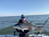
Went out to the sandy hook rip this morning to fish for strippers. Caught one dink. I notice the point appears to much smaller and the green buoy is much farther out from shore. Does anyone know if the area was dredged or was buoy moved? Last fall if you had a long cast at low tide. You could almost reach the buoy. Also the dunes are much closers the point too. FYI they moved the roped off area for bird nesting all the out to the end.
Mar 31, 2020 14:47:06 #

On LBI officials have restricted access to some areas to protect ground nesting Piping Plovers. Unfortunately, hungry foxes didn't get the message. They resorted to trapping foxes. That's put some of the locals in a quandary - they want to protect the birds. But some of them have sorted of adopted the foxes - even feed them.
Mar 31, 2020 14:58:34 #

oldsalt wrote:
On LBI officials have restricted access to some areas to protect ground nesting Piping Plovers. Unfortunately, hungry foxes didn't get the message. They resorted to trapping foxes. That's put some of the locals in a quandary - they want to protect the birds. But some of them have sorted of adopted the foxes - even feed them.
When we did a beach cleanup after the hurricane the park service people told me there were no foxes in the Holgate reserve area. That was really funny since i had seen about a dozen sets of tracks in the area over the four hours walking around collecting debris. On the other end of the island near the lighthouse I've seen as many as 5 foxes sitting there waiting for some to leave a bait cooler open. And that's not counting the coyote I saw from 10 feet away in Harvey Cedars one night.
By the way the buoy more than likely didn't move, the point did because of erosion in a storm.
Apr 1, 2020 07:11:12 #
FixorFish
Loc: SW Oregon
Any one of the three of you above wanna give the rest of us a clue as to WHERE YOU ARE TALKING ABOUT ? You all seem to know, yet I see Pennsylvania, and Delaware and the originator of the thread, who knows ?? LBI ?? Holgate ??? Harvey Cedars ???
Apr 1, 2020 07:43:41 #
FixorFish wrote:
Any one of the three of you above wanna give the rest of us a clue as to WHERE YOU ARE TALKING ABOUT ? You all seem to know, yet I see Pennsylvania, and Delaware and the originator of the thread, who knows ?? LBI ?? Holgate ??? Harvey Cedars ???
Sorry. Went into local mode. Sandy Hook is in central NJ right out side New York harbor at the mouth of the Hudson River. The rest are areas of Long Beach Island which is about 60 miles south on the Jersey coast.
Apr 1, 2020 07:55:01 #
FixorFish
Loc: SW Oregon
Thought for a minute, I was somehow EAVESDROPPING on a conversation I wasn't privy to. Thanks for the clarification....was gonna guess "London Bridge Inlet"?? Lol !
Apr 1, 2020 10:07:27 #
greenfrog
Loc: Central NJ
As stated the sand is always shifting at the tip. You just have to look at the lighthouse to see.
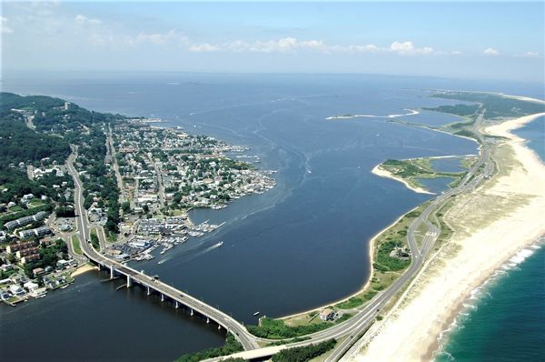
The Sandy Hook Lighthouse, located about one and a half statute miles (2.4 km) inland from the tip of Sandy Hook, New Jersey, is the oldest working lighthouse in the United States. It was designed and built on June 11, 1764 by Isaac Conro. At that time, it stood only 500 feet (150 metres) from the tip of Sandy Hook; however, today, due to growth caused by littoral drift, it is almost one and a half miles (2.4 km) inland from the tip.
Are you saying the rip is closed already due to the piping plovers? Seems quite early.
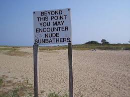
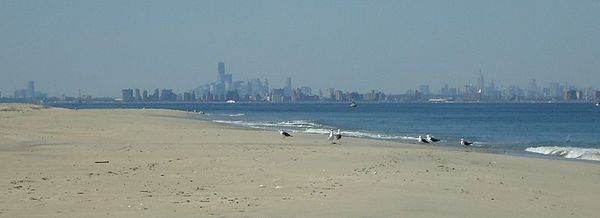
Some pictures of Sandy NJ
The Sandy Hook Lighthouse, located about one and a half statute miles (2.4 km) inland from the tip of Sandy Hook, New Jersey, is the oldest working lighthouse in the United States. It was designed and built on June 11, 1764 by Isaac Conro. At that time, it stood only 500 feet (150 metres) from the tip of Sandy Hook; however, today, due to growth caused by littoral drift, it is almost one and a half miles (2.4 km) inland from the tip.
Mike emmel wrote:
FYI they moved the roped off area for bird nesting all the out to the end.
Are you saying the rip is closed already due to the piping plovers? Seems quite early.
Some pictures of Sandy NJ
Sandy Hook
Gunnison Beach

New York City skyline, with the new tower emerging in the financial district (middle, slight left), Jersey City buildings (far left) and the Empire State building and midtown (to the right).
Apr 1, 2020 10:20:07 #
As oceans rise, that light house will probably be under water in another 50 years.
Apr 1, 2020 10:22:51 #
The rip isn’t closed. Just they have a string fence just about all the way out to end
Apr 1, 2020 14:29:47 #
kvothe
Loc: West Deptford new jersey, but the salt calls
Insane feeding wildlife, they ste terrible a IBSP
Apr 1, 2020 14:30:37 #
kvothe
Loc: West Deptford new jersey, but the salt calls
Say, dod you ever see any sheephead caught up in that area
Apr 1, 2020 17:56:58 #

Sandy Hook would have reached Staten Island 100 years ago if they didn't continuously dredge. I would try the back of Raritan Bay for stripers right now.
Apr 3, 2020 17:58:05 #
Where do get shore access to back of raritan bay? Off of hwy 36 ?
Apr 3, 2020 18:45:06 #
Yes and don't overlook the western end of the bay which is off Rte 35 in Middlesex County. Cliffwood Beach and Lawrence Harbor in particular.
Apr 3, 2020 19:13:48 #
Ok thanks. Where would you suggest to start? I normally fish the rip and c beach in the gateway park. I also Kayak fish the bay around coastguard station
If you want to reply, then register here. Registration is free and your account is created instantly, so you can post right away.