Lake topograph
Nov 12, 2021 23:55:17 #

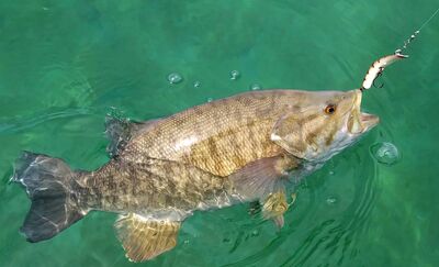
Ever really study a lake Topo map?
I like to eliminate a lot of the lake up front based on seasonal patterns I’ve come to learn
Common logic says pre spawn bass should be holding in certain areas. That kinda thing
Last year i decided to try a little wintertime spillway saugeye action
Well the access gate was closed so I had quite a hike down the access road
During this hike I got a better appreciation of the extremely rugged the terrain is. .
This rugged terrain extends to form the bed of the lake when someone decided to build a dam back in the 60s
This lake is the deepest in Ohio at just over 100 ft and is fed by a creek known as Caesar creek
And the lake has the same name.
Very technical lake. And basically barren extremely drastic elevation changes.
I can have the front of my 19 ft boat in 20 ft of water and the back is in 35 ft.
By barren I mean it looks like it was manicured by excavation before flooding.
There are a few good pockets of standing timber , and a few very small rock piles , and that’s it
Only aquatic vegetation aside from the occasional very sparse submerged grass . Is a couple acres of Lilly’s in 3 ft of water , tucked way back in a cove.
Strangely, I’ve never caught a bass off the lads there
The lake isn’t known for its bass population.
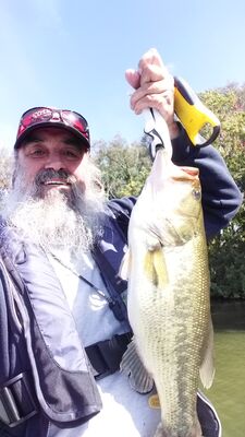
A tournament I checked on last year had a winning weight of like 7-6 but the guy had a 6-7 that won big bass.
Lake has massive schools of white bass that are a blast to catch ! and in late summer really tight groups of crappie are around I’d you know where to look. Turns out even when you find em ya really can’t turn em on. Learned this this year.
I’ve got about 135 waypoints marked on this lake and I bet 40% of them , fewer than 20 other people even know to look there honeyholes when the timings right
Take a good close look at A good topo. Eliminate any areas that don’t fit seasonal patterns, and really focus on areas that fit the circumstance
I’ve got maps with areas targeted by color code . Yellow for spring , red for summer …
Then go out with your electronics and start to pick it apart.
Start with just a broad search then really focus on the sweet spot you found.
I like to eliminate a lot of the lake up front based on seasonal patterns I’ve come to learn
Common logic says pre spawn bass should be holding in certain areas. That kinda thing
Last year i decided to try a little wintertime spillway saugeye action
Well the access gate was closed so I had quite a hike down the access road
During this hike I got a better appreciation of the extremely rugged the terrain is. .
This rugged terrain extends to form the bed of the lake when someone decided to build a dam back in the 60s
This lake is the deepest in Ohio at just over 100 ft and is fed by a creek known as Caesar creek
And the lake has the same name.
Very technical lake. And basically barren extremely drastic elevation changes.
I can have the front of my 19 ft boat in 20 ft of water and the back is in 35 ft.
By barren I mean it looks like it was manicured by excavation before flooding.
There are a few good pockets of standing timber , and a few very small rock piles , and that’s it
Only aquatic vegetation aside from the occasional very sparse submerged grass . Is a couple acres of Lilly’s in 3 ft of water , tucked way back in a cove.
Strangely, I’ve never caught a bass off the lads there
The lake isn’t known for its bass population.
A tournament I checked on last year had a winning weight of like 7-6 but the guy had a 6-7 that won big bass.
Lake has massive schools of white bass that are a blast to catch ! and in late summer really tight groups of crappie are around I’d you know where to look. Turns out even when you find em ya really can’t turn em on. Learned this this year.
I’ve got about 135 waypoints marked on this lake and I bet 40% of them , fewer than 20 other people even know to look there honeyholes when the timings right
Take a good close look at A good topo. Eliminate any areas that don’t fit seasonal patterns, and really focus on areas that fit the circumstance
I’ve got maps with areas targeted by color code . Yellow for spring , red for summer …
Then go out with your electronics and start to pick it apart.
Start with just a broad search then really focus on the sweet spot you found.
Nov 13, 2021 00:31:14 #
stuco
Loc: Northern Utah - Salt Lake City
Good stuff Ben, thanks for sharing. I barely got out this year except to fish from the shore at lakes I know pretty well. I intend to do a bit more exploring of places I haven’t been next year. I like this approach.
Nov 13, 2021 07:33:30 #

Great post Ben! Lots of good info.
Quite often I have noticed that a lake has very similar contours as the surrounding land. If there is a gentle slope leading into the water, there is often a gentle slope beneath the surface. If a steep slope, there could be a deep drop off. Conversely speaking, if the land is flat, the shallow water could extend quite a ways out. Pay attention to the surrounding areas. This of course applies to natural lakes and not man-made ponds.
Quite often I have noticed that a lake has very similar contours as the surrounding land. If there is a gentle slope leading into the water, there is often a gentle slope beneath the surface. If a steep slope, there could be a deep drop off. Conversely speaking, if the land is flat, the shallow water could extend quite a ways out. Pay attention to the surrounding areas. This of course applies to natural lakes and not man-made ponds.
Nov 13, 2021 08:24:38 #
Good insight and information! Topographic maps are awesome when getting to know a body of water. Although "electronic" maps from sonar dominate our applications these days, I still enjoy finding old paper copies of lakes that I fish that show items like submerged structure etc. that was done eons ago by local folks or Fish and Game departments.
Many of these old maps were simply hand drawn by local fishermen, and based on local knowledge, which makes them even more useful!
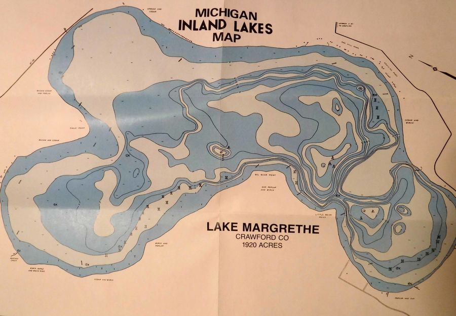
I picked up the attached map a few days ago while shopping in Skip's Sporting Goods store (Grayling, MI) to stock up on a few trout flies. I happened to notice this map near the check out for just a few dollars. You typically will not find this type of map at any "big box" store, so just keep your eyes open when shopping at regular, locally owned tackle shops!
.
Many of these old maps were simply hand drawn by local fishermen, and based on local knowledge, which makes them even more useful!
I picked up the attached map a few days ago while shopping in Skip's Sporting Goods store (Grayling, MI) to stock up on a few trout flies. I happened to notice this map near the check out for just a few dollars. You typically will not find this type of map at any "big box" store, so just keep your eyes open when shopping at regular, locally owned tackle shops!
.
This lake is located about 3 miles West of Grayling, MI
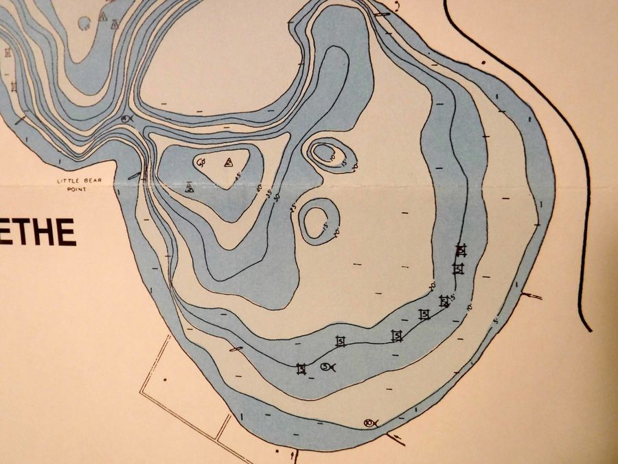
Enlarged area showing the detail where fish structure was placed.
Nov 13, 2021 09:27:43 #
Ben Bragg wrote:
Ever really study a lake Topo map? br I like to e... (show quote)
Thanks for sharing you knowledge and tactics. I plan to put them into practice and hopefully catch more!
I have some map books I received for Christmas. They are pretty accurate and come with spot and technique suggestions. I believe they make them for all 50 states. They also came with down loads to put a tablet or computer.

Nov 13, 2021 09:54:38 #
Ben Bragg wrote:
Ever really study a lake Topo map? br I like to e... (show quote)
You're absolutely correct Ben, learning the layout of the bottom of the lake is probably more important than the surface features. I always look for a Topo map before I hit a new lake. I make a small hard copy, with notes and features highlighted . I take it with me on a clipboard, for reference all day. Electronic charting is great, but I like a paper chart for the big picture, even if I may need a magnifier to see the details,LOL.
Nov 13, 2021 11:32:35 #

When I lived in N.H. I carried a
loose-leaf binder with me with
clear plastic sheets in which
I kept bathymetric charts
(depth maps) of whichever ponds/lakes I was planning
on fishing !
N.H. F & G has over 600 fishing
maps on their website, so
I would go to the library, zoom
in on whichever map I wanted
and print a copy for my folder !
Too bad other states don't 'follow suit', as I would love to find maps
of certain lakes here in Arizona !
I can get those plastic-coated 'waterproof' maps at BPS or Sportsman's Warehouse, but balk
at their prices at $12/map - I'd
much rather find them for free !
Don't currently have a good source
for them, but sometimes I get lucky and find one or two on the 'net' !
Nov 13, 2021 12:13:43 #
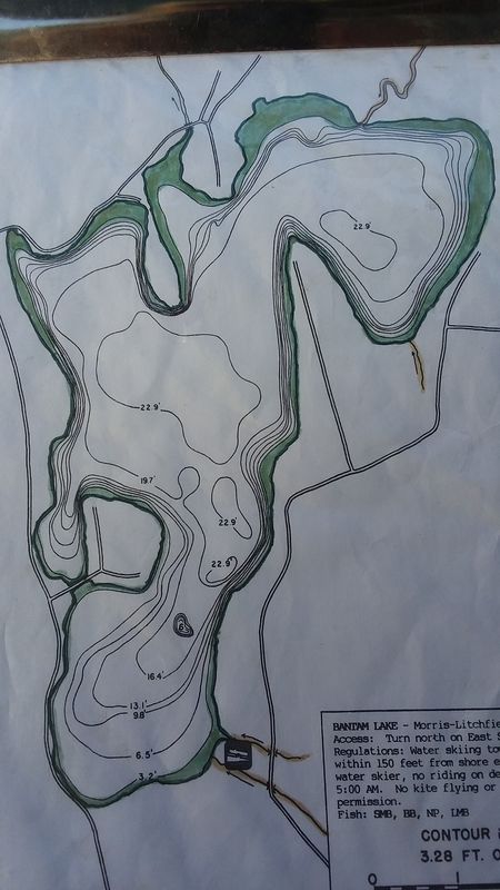
I have 2 of the "Fishing Hot Spots " waterproof maps, of the only lakes in Ct. that they make. Lillinonah, and Candlewood, the 2 biggest lakes in the state. If I printed regular 8x11 pages they would be tiny, or 6-10 pages each. I just fold them down to show the area I'm gonna fish, and then refold when I move to a different area. All the other lakes are smaller, and a single page works out well. Like this one of Bantam Lake, where I'm thinking of going tomorrow.
I color out to the 1st contour line in green, so I don't forget where the shallows are.
Nov 13, 2021 12:43:33 #
Yea. GPS mapping on today’s depth finders is awesome. And I added an upgrade card to my Garmin that has depth range coloring.
Butold fashioned map the night or days before the trip can eliminate a whole lot of unproductive water quickly
Of course , the fish don’t always think the same as I do and go where they aren’t supposed to be. Stupid fish!
Butold fashioned map the night or days before the trip can eliminate a whole lot of unproductive water quickly
Of course , the fish don’t always think the same as I do and go where they aren’t supposed to be. Stupid fish!
Nov 13, 2021 12:45:41 #
J in Cleveland wrote:
Thanks for sharing you knowledge and tactics. I plan to put them into practice and hopefully catch more!
I have some map books I received for Christmas. They are pretty accurate and come with spot and technique suggestions. I believe they make them for all 50 states. They also came with down loads to put a tablet or computer.
I have some map books I received for Christmas. They are pretty accurate and come with spot and technique suggestions. I believe they make them for all 50 states. They also came with down loads to put a tablet or computer.
Those are great books J! The bugger about Michigan is that it takes 7 of them to cover the whole State! Still a very good investment and I use them extensively!
We spend enough on tackle...so why not shell out a little more for good maps...right!
Nov 13, 2021 12:47:08 #
Ben Bragg wrote:
Yea. GPS mapping on today’s depth finders is awesome. And I added an upgrade card to my Garmin that has depth range coloring.
Butold fashioned map the night or days before the trip can eliminate a whole lot of unproductive water quickly
Of course , the fish don’t always think the same as I do and go where they aren’t supposed to be. Stupid fish!
Butold fashioned map the night or days before the trip can eliminate a whole lot of unproductive water quickly
Of course , the fish don’t always think the same as I do and go where they aren’t supposed to be. Stupid fish!
LOL, I think all fish should be required to take a map reading course, so they'll know where to hang out.

Nov 13, 2021 15:05:14 #
Fredfish wrote:
I have 2 of the "Fishing Hot Spots " waterproof maps, of the only lakes in Ct. that they make. Lillinonah, and Candlewood, the 2 biggest lakes in the state. If I printed regular 8x11 pages they would be tiny, or 6-10 pages each. I just fold them down to show the area I'm gonna fish, and then refold when I move to a different area. All the other lakes are smaller, and a single page works out well. Like this one of Bantam Lake, where I'm thinking of going tomorrow.
Good idea highlighting the shallows, especially if they're 5 feet or less -
doing same to any 'high spots'
(rocky shallows) in the lake would
also be helpful in avoiding the possibility of prop damage or
accident !
Nov 13, 2021 15:10:51 #
Big A wrote:
Good idea highlighting the shallows, especially if they're 5 feet or less -
doing same to any 'high spots'
(rocky shallows) in the lake would
also be helpful in avoiding the possibility of prop damage or
accident !
doing same to any 'high spots'
(rocky shallows) in the lake would
also be helpful in avoiding the possibility of prop damage or
accident !
I do that as well Big. Some maps show boulder fields as well, but sadly most don't. Whenever i'm in doubt, tilt up the Merc, and go in on the trolling motor. Plastic props are much cheaper than aluminum ones.
Nov 13, 2021 15:35:20 #
fishyaker wrote:
Those are great books J! The bugger about Michigan is that it takes 7 of them to cover the whole State! Still a very good investment and I use them extensively!
We spend enough on tackle...so why not shell out a little more for good maps...right!
We spend enough on tackle...so why not shell out a little more for good maps...right!
Wife said she got them for less than $20 each. I spend that waking passed CABELAS. lol well worth it!
Nov 13, 2021 18:59:41 #

If you want to reply, then register here. Registration is free and your account is created instantly, so you can post right away.